Property Record
767 Route 70 E, Marlton, NJ 08053
This Property Is For Sale
NEARBY LISTINGS FOR SALE OR LEASE
Property Detail
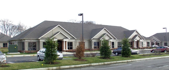
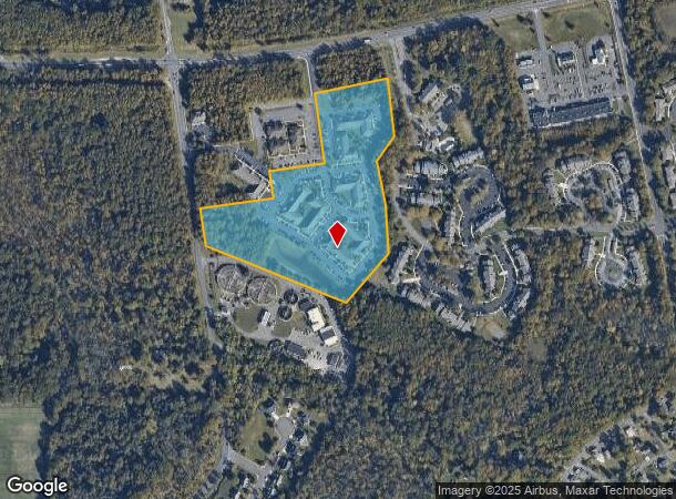
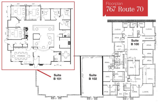
767 Route 70 E
13-00019-01-00003-0000-C0767
Elmwood Office Condo
Officecondo
Burlington
X
New Jersey
34005C0244F
3
2024
South Burlington County
2025
Philadelphia
704005
Philadelphia-Camden-Wilmington, PA-NJ-DE-MD
10,695 SF
DEMOGRAPHICS near 767 Route 70 E
1 Mile
3 Mile
5 Mile
2024 Total Population
8,411
53,488
126,098
2029 Population
8,595
54,537
127,739
Pop Growth 2024-2029
+ 2.19%
+ 1.96%
+ 1.30%
Average Age
42
43
43
2024 Total Households
3,427
21,154
49,375
HH Growth 2024-2029
+ 2.25%
+ 2.04%
+ 1.30%
Median Household Inc
$109,749
$115,904
$122,730
Avg Household Size
2.40
2.50
2.50
2024 Avg HH Vehicles
2.00
2.00
2.00
Median Home Value
$331,390
$357,298
$358,759
Median Year Built
1995
1986
1984
Nearby Places
- Restaurants
- Banks
- Shops
- Fitness
- Groceries
PUBLIC TRANSPORTATION
COMMUTER RAIL
Lindenwold (NJT) (Atlantic City Line - NJ Transit Commuter Rail (NJ Transit))
DRIVE
WALK
Distance
Lindenwold (NJT) (Atlantic City Line - NJ Transit Commuter Rail (NJ Transit))
19 min
9.6 mi
Cherry Hill (Atlantic City Line - NJ Transit Commuter Rail (NJ Transit))
DRIVE
WALK
Distance
Cherry Hill (Atlantic City Line - NJ Transit Commuter Rail (NJ Transit))
15 min
9.9 mi
AIRPORT
Philadelphia International
DRIVE
WALK
Distance
Philadelphia International
39 min
25.7 mi
Trenton Mercer
DRIVE
WALK
Distance
Trenton Mercer
54 min
35.6 mi
Atlantic City International
DRIVE
WALK
Distance
Atlantic City International
78 min
43.5 mi
Nearby Properties
Address
Land Use
TOTAL SIZE
Lot Size
Zoning
Address
Land Use
TOTAL SIZE
Lot Size
Zoning
1,896 SF
93.79 AC
LD
Address
Land Use
TOTAL SIZE
Lot Size
Zoning
50.60 AC
PPE
Address
Land Use
TOTAL SIZE
Lot Size
Zoning
53.35 AC
LD
Address
Land Use
TOTAL SIZE
Lot Size
Zoning
44.80 AC
C-1
Address
Land Use
TOTAL SIZE
Lot Size
Zoning
5 AC
C-1
Address
Land Use
TOTAL SIZE
Lot Size
Zoning
58.48 AC
MD
Address
Land Use
TOTAL SIZE
Lot Size
Zoning
52.30 AC
MD
Address
Land Use
TOTAL SIZE
Lot Size
Zoning
Address
Land Use
TOTAL SIZE
Lot Size
Zoning
2,600 SF
37.38 AC
AH-1
Address
Land Use
TOTAL SIZE
Lot Size
Zoning
Address
Land Use
TOTAL SIZE
Lot Size
Zoning
9.38 AC
C-1
Address
Land Use
TOTAL SIZE
Lot Size
Zoning
42.80 AC
MF
Address
Land Use
TOTAL SIZE
Lot Size
Zoning
25.28 AC
C-1
Address
Land Use
TOTAL SIZE
Lot Size
Zoning
23.43 AC
INS
Address
Land Use
TOTAL SIZE
Lot Size
Zoning
2,264 SF
17.30 AC
C-1
Address
Land Use
TOTAL SIZE
Lot Size
Zoning
31.88 AC
MD
Address
Land Use
TOTAL SIZE
Lot Size
Zoning
10.38 AC
C-1
Address
Land Use
TOTAL SIZE
Lot Size
Zoning
1,416 SF
16.88 AC
C-1
Address
Land Use
TOTAL SIZE
Lot Size
Zoning
5,484 SF
12.90 AC
C-1
Address
Land Use
TOTAL SIZE
Lot Size
Zoning
13,636 SF
23 AC
HC-1
Address
Land Use
TOTAL SIZE
Lot Size
Zoning
140.84 AC
MD
Address
Land Use
TOTAL SIZE
Lot Size
Zoning
5.52 AC
AH1A
Address
Land Use
TOTAL SIZE
Lot Size
Zoning
10,000 SF
10.80 AC
RD-1
Address
Land Use
TOTAL SIZE
Lot Size
Zoning
22.74 AC
HC-1
Address
Land Use
TOTAL SIZE
Lot Size
Zoning
26.16 AC
MF
Address
Land Use
TOTAL SIZE
Lot Size
Zoning
77,718 SF
10.90 AC
RR
Address
Land Use
TOTAL SIZE
Lot Size
Zoning
128.02 AC
PPE
Address
Land Use
TOTAL SIZE
Lot Size
Zoning
Address
Land Use
TOTAL SIZE
Lot Size
Zoning
11.54 AC
MD
Address
Land Use
TOTAL SIZE
Lot Size
Zoning
46.66 AC
AH3
The World's #1 Commercial Real Estate Marketplace
Connect with us
© 2025 CoStar Group
The information above has been obtained from sources believed reliable. While we do not doubt its accuracy we have not verified it and make no guarantee, warranty or representation about it. It is your responsibility to independently confirm its accuracy and completeness. Any projections, opinions, assumptions, or estimates used are for example only and do not represent the current or future performance of the property. The value of this transaction to you depends on tax and other factors which should be evaluated by your tax, financial, and legal advisors. You and your advisors should conduct a careful, independent investigation of the property to determine to your satisfaction the suitability of the property for your needs.